GRO (St Cath's) Indexes:
*disclaimer
Births
Marriage
Death
- The 'Great
Escape'
&
F/Lt.
E. G. Brettell
- The MacDuff Brettells
- Brettell-Vaughan
- Brettle & Co Belper
Brettell, the settlement, now called Hawbush,
is due north of Amblecote (West Midlands). Paul Henzey, a Protestant
Lorrainer and glassmaster, escaped from France
with other Frenchmen in the late 16th century and went to the 'Stourbridge' area
when King James Ist put a ban on Glassmakers using charcoal for their
furnaces in 1617 . He started work
in Oldswinford, using local coal
then moved to Amblecote and finally to Brettell which
was
the centre of the coal field. The
Henzey family made Brettell their main home and intermarried with
the local families including the Brettell's. It was one of the Henzey's
who changed the place-name Brettell to Hawbush
(information supplied by John Hemingway, Archaeological Officer,
Dudley Archives) ... see full details
A search of UK Street names at http://www.streetmap.co.uk/ reveals the following addresses:
BRETTELL LANE, BRIERLEY HILL,WEST MIDLANDS,DY5
BRETTELL LANE, DY5
BRETTELL LANE, STOURBRIDGE,WEST MIDLANDS,DY8
(The above being all different versions of the same Brettell
lane)
- Maps depicting Brettell lane (Thanks once again to Mel SHAW)
Map of Audenham with Brettell - 1750 (PDF) from Dudley Archives
From PUB AND BEER GUIDE FOR THE MIDLANDS
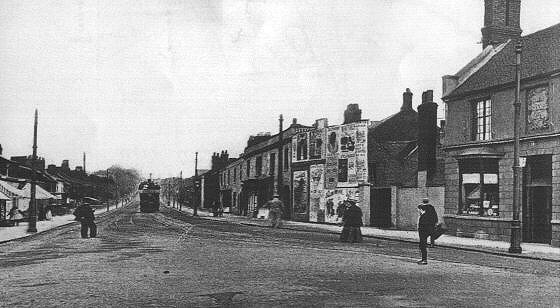
The main road through Silver End is Brettell Lane, part of the busy old ridge road running from Dudley through Brierley Hill and down to the old glassworks industries at Audnam and Amblecote. The road was originally a turnpike and was designated as such in 1727 but was eventually made a 'free' public highway in 1871. Unfortunately, the attractive tollhouse which stood here was demolished shortly after the Second World War. Whilst it is thought that the road may be named after the Brettell family, it is more likely that it's name is derived from the fact that it led to Silver End which was once known as Brettell which, in turn, may be a corruption of Bredhulle - an ancient name for the hill or ridge on which Silver End stands
Amblecote History Society has a link to Streets in the area, including Brettell Lane
From Jason Ellis, author of Glassmakers of Stourbridge and Dudley 1612-2002
Brettell Lane is a road, almost one mile long, in the glassmaking area, just north of the town of Stourbridge. At its Western end it meets the main Stourbridge to Wolverhampton road in the very heart of the glassmaking district in Amblecote. It rises up the hillside of what was once the Pensnett Chase, crosses the canal that was built to service the local glassmaking and ironmaking activities, crosses the railway line, which was
once the route of the Oxford, Worcester and Wolverhampton Railway and terminates at the junction of Bull Street and Church Street, which continues into Brierley Hill.
In some ancient documents it is occasionally spelt Brittell Lane, probably a phonetic misinterpretation which could explain your census entry of Britlane. However, its proper spelling is most definitely Brettell Lane and is associated with an ancient family of that name.
During the late seventeenth, eighteenth and early nineteenth centuries coal and clay were mined south and north of Brettell Lane, this developing into an industrial community which also began to be known as Brettell Lane. In the seventeenth and eighteenth centuries several glassworks were built alongside Brettell Lane due to the availability of raw materials... Brettell Lane is both a road and a district encompassing the businesses that lay immediately north and south of the road.
As for counties nothing could be more confusing. The eastern end is in Brierley Hill which is ecclesiastically and territorially in Staffordshire. The western end is in Amblecote. Amblecote has always been a great anomaly, being parochially in Oldswinford and Worcestershire, but territorially in the county of Stafford. It appears in Domesday Book and was historically a hamlet in Oldswinford parish until it became a separate ecclesiastical parish in the diocese of Worcester in 1845. The building of Amblecote Church began in August 1841 at Holloway End . It was opened in 1842 and consecrated in November 1844. This new parish of Amblecote incorporated the township of Wollaston until 1860 when St. James’ Church was built and Wollaston became a separate parish. Administratively, Amblecote converted from a parish council to an urban district council in 1894 when it was the smallest urban district council in the country with an area of just 665 acres. It remained as an administrative area until 1966 when it was divided between Stourbridge and Brierley Hill.
Source: http://archiver.rootsweb.ancestry.com/th/read/STAFFORDSHIRE/2003-02/1046217181
From Kath Connors, a Brettell descendant:
"Joseph Cartwright Brettell was Mayor of Dudley in 1830. He was a mine surveyor & went to the Middle East searching for tin and oil until they were hunted out by the then powers to be."
A search of UK Street names at http://www.streetmap.co.uk/ also reveals the following addresses:
BRETTELL STREET, DUDLEY,WEST MIDLANDS,DY2
From John Hemingway, Archaeological Officer, Dudley Archives:
This street runs off Well Street, not far from where it crosses Stourbridge Road (A4101)
BRETTELL LANE, Stourbridge, West Midlands
From John Hemingway, Archaeological Officer, Dudley Archives:
BRETTELL ROAD, LEICESTER,LE2
This street runs between Whitteney Drive and Pasley Road Leicester near to Glenhills Way (A563)
and
BRETTELL STREET, LONDON,SE17 (Walworth)
Walworth, SE17, is part of the London borough of Southwark and borders on to Camberwell and Kennington. The modern Brettell Street runs NNW-SSE from Aylesbury Road at the northern end to Merrow Street and is not far from St Peters church where Catherine Louise Brettell was married in 1895. As these Brettells do not seem to have been of great significance I do not believe the street was named after them.
The Southwark Local Studies Library, which holds the local history collection of the Borough of Walworth, cannot explain the choice of the name.
Comparing the 1894 Booth against the 1862 Stanford map (online at Motco) indicates no street in this location. Comparing the present day location against the Booth & Stanford indicates that the locale has been significantly altered and no such street or alignment presents itself. Most of the current street names do not exist on the 1862 map, the entire area seems to have been altered, the streets renamed and new ones created. The current Brettell Street would have run between what was then Shaftesbury Street and Clarendon Street and the only landmark in this area in 1862 was St Peter's Nat Schools.
On Charles Booth's Poverty map of London produced in 1889 the area looks much the same as it did in 1862 - EXCEPT for Brettell Street - running between Portland Street and Villa Street (right in the centre of the map). In 1862 this street was called Guildford Street (and would now appear to be an extension of Merrow Street).
Brettell Street Walworth was Guildford Street in the 1881 census (London/Newington/St Peter, Walworth/ District 22d). It appears as Brettell Street in the 1891 census. In both censuses it was off Villa Street (between Villa and Portland St).
Brettell Street existed on Charles Booth's survey of London map of 1899.
In the 1901 census Brettell Street ran off Portland Street.
(St Peter,
Walworth Civil Parish Newingnton, County of London RG13/379 District 21)
Victorian London - Streets
- B:
Source: GENDOCS
Brettell Street WALWORTH [Charles Booth's Survey of London
1899]
Brettell Street, Walworth SE17 [Royal Mail Postcode CD-ROM 1997]
The houses/flats shown in the picture below, together with many in that area, belong to the Church Commissioners. Canterbury Cathedral gave their land in Walworth to Church Commissioners in 1862. They were managed in the late 1800s by Miss Octavia Hill, the reformer who was instrumental in the founding of the National Trust. Miss Hill was a passionate advocate for housing which made a reasonable return for the Church's mission and these dwellings now form part of the 'Octavia Hill' Estates.
Walworth was bombed during the Blitz of 1940. Many buildings in the Walworth area were demolished by the London County Council and Greater London Council redevelopment between 1958 and 1965. I suspect this might have been when the name Brettell street was reallocated. Visit Walworth History Web Page.
Conclusion? The original Brettell Street came into being between 1881 and 1889 and I have no idea when it came to be in it's current location.
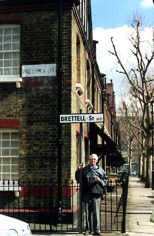
My
Dad, Ray Brettell, in Brettell Street Walworth, 2001.